Watershed Boundary Map of Prince Edward Island

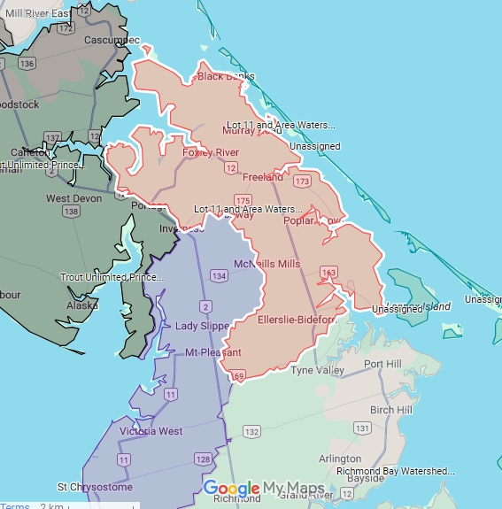
The Lot 11 and Area Watershed Mangement Group Inc. is located in Prince County in the province of Prince Edward Island, Canada. It includes the communities of Black Banks, Conway, East Bideford, Foxley River, Freeland, Murray Road, and Poplar Grove. It is on the Gulf of Saint Lawrence seaboard with approximate coordinates: 46.66N°, 63.95W°.
Watershed Management Area
Location: Prince Edward Island, Canada
Municipal areas: Lot 11 & Area, Central Prince
Geographic center: 63.99W, 46.64N
Nine watersheds, (10 primary streams, 18 smaller streams)
Total Area: 15,309 hectares
Our group’s area of management includes nine geophysical watersheds: Black Banks, Foxley River, Freeland Creek, Brook’s River, Cranberry Point, Josephine Shore, Bideford River, Conway Sand Hills, and Enmore River East. It has ten independent principal streams and ~18 smaller streams. The principal streams are MacDonald’s River, Canadian Creek, Foxley River, Gains Creek, Freeland Creek, Brook’s River, Southwest Creek, Grant’s Brook, Ellerslie Brook, and the Enmore River. The Conway Sand Hills watershed is entirely natural sand dune wetland.
The individual watersheds located in the group’s managed area are tabulated below, with their areas.
Watershed Area, Ha
FOXLEY RIVER 4243.35
BLACK BANKS 1557.17
FREELAND CREEK 1097.45
BROOKS RIVER 2035.55
BIDEFORD RIVER 3411.16
JOSEPHINE SHORE 546.94
CRANBERRY POINT 283.23
ENMORE (EAST OF RT.2) 2133.92
TOTAL 15309 Ha (153 SQUARE KILOMETERS)
LAND COVER CHARACTERISTICS
| Forest and Wetland | Agriculture and development | |
| Lot 11 Watershed Group Area | ~83% | ~17% |
| Island Wide | ~37% | ~63% |
These forest and wetland areas are responsible for the area’s excellent groundwater quality.
Our ground water is our single source of drinking water for our communities. These forest and wetland resources act in two primary ways to keep our groundwater clean. First, because these areas are there instead of agriculture and development, the opportunity and extent of contamination from land uses is limited. Second, the wetlands provide a natural trap for nutrients and other contaminants. The wetland resources also stabilize groundwater levels. The swamps and marshes of the region store vast quantities of groundwater for both drinking water resources and stream flow regulation.
Finally, the forest and wetland resources provide wildlife habitat. The term wildlife encompasses all non-domesticated plants, animals and microorganisms. Watershed wildlife communities are an essential component for man human stakeholders. They are part of the overall global system that supports life, and they provide aesthetic and cultural enrichment. Often, they have immediate economic value too. Wildlife populations are natural resources that comprise our biological wealth. Natural systems and wildlife are important on their own, independent of human values.